
Waikato District Council hopes to have about $750,000 of Central Government TEFAR funding, aimed at improving road safety and wants to decide priorities for spending the money it gets from this map of schemes. The plans show additional walkways and cycleways around Raglan as possible priorities for the new money.
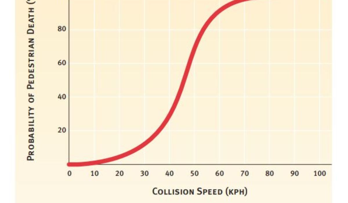
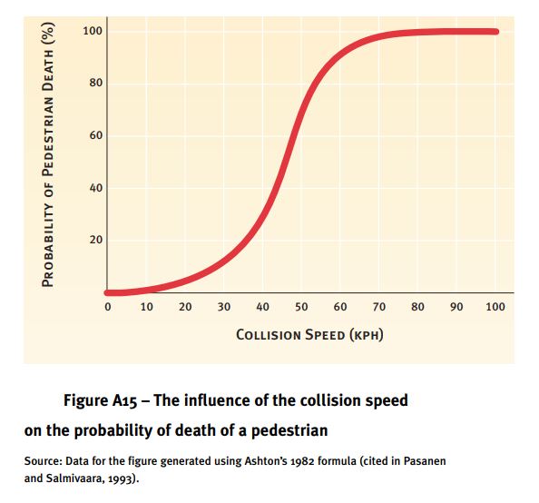
WDC plans a consultation period in Oct-Nov, linked with 40kph speed limit proposals for most of Raglan. John Lawson of Whaingaroa Environmental Defence says that by then a lot of work will have been done. So he asking people, “What do you think now? Would you like a WED meeting to discuss the options?” This graph shows the reason for 40kph (from page 27 of Transport Ministry paper) – would 30kph be better?
At a meeting held in Raglan on 19th July, these ideas were put to WDC By WED and other members of a group convened by the council –
- The route from town to the beach should follow the beach from the airfield and include a sea wall in the area being eroded near the Kokiri Centre. WDC thought this would be too controversial. Do you agree, or do you see it as a route more likely to attract walkers and cyclists by being shorter, more attractive and flatter, whilst offering landowners protection from erosion?
- Other suggestions were –
- a less steep route through the Wainui Reserve
- a link closer to Wainui Stream from Wainui farm entrance to Friends of Wainui car park and consultation with FoW
- a link at the end of Taipari Ave to Wainui Rd
- widen the footpath on Aerodrome Bridge, Marine Pde for walkers and cyclists
- safe routes to school along Norrie Ave (WDC suggested this will be for a future round of funding)
- a link from Wi Neera St to the footbridge
- to be on the harbour side of Cliff St, rather than the land side of the road
- a boardwalk from rugby club car park to Wallis St, as mentioned in a 2013 WDC report saying, “it may be possible to create a walkway from the parking area to Wallis Street”.
- from the foot of Violet St to link with the paper road from Primrose St
- consider sharrows, or a woonerf for Cambrae Rd, where the road is too narrow for a separate walkway/cycleway
- add a plank for cycles besides the Cambrae Rd to Lorenzen Bay steps
- ease the gradient between Greenslade Rd and Nikau Park (there’s also a direct link to Lorenzen Bay on the District Plan map)
- include the direct link from Greenslade Rd to Lorenzen Bay
If you have thoughts on this let John Lawson of WED know. John asks, “What do you think? What would your priorities be? Would you prefer 3m wide concrete paths for shared use, or rather more paths of a lower standard? What have I missed? “
John Lawson, Secretary, Whaingaroa Environmental Defence Incorporated 51 Cliff St, Raglan 07 825 7866 email johnragla@gmail.com