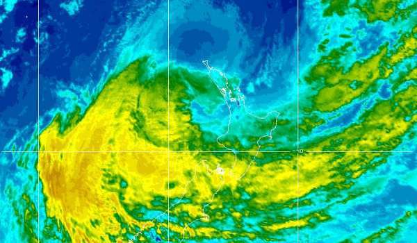
Raglan has been buffeted by strong winds on Saturday afternoon with light showers. Raglan Weather recorded 5.6mm of rain in the last 24 hours. There is now weather warning for the Raglan land area but the Raglan Marine area has a gale warning.
To the north, gale force winds have resulted in more than 7700 Vector customers also had their power out around the Auckland area today, with crews working to reconnect residents. Those affected were in Waimauku, Whitford, Omaha, Cockle Bay, Remuera , Stanmore Bay, Arkles Bay, Red Beach, Wellsford and Port Albert.
SEVERE WEATHER WARNING.
ISSUED BY MetService AT 12:17pm 15-Mar-2014 URGENT – IMMEDIATE BROADCAST IN: Northland, Coromandel Peninsula, Bay Of Plenty Rotorua, Gisborne, Hawkes Bay, Nelson, Marlborough, Canterbury, Otago, Auckland, Waikato, Wairarapa, Wellington
CYCLONE LUSI WILL BRING HEAVY RAIN AND EASTERLY GALES TO MANY PLACES THIS WEEKEND. HEAVY RAIN WARNINGS FOR SOUTH CANTERBURY AND NORTH OTAGO NOW ADDED. SEVERE NORTHWEST GALE WARNINGS ADDED FOR MARLBOROUGH WELLINGTON AND WAIRARAPA FROM SUNDAY EVENING.
A depression formerly Tropical Cyclone Lusi lies just north of New Zealand this morning and is expected to be centred about 300km west of Auckland at midnight tonight. The low will then move southwards to cross northern parts of the South Island Sunday evening. Widespread rain and easterly gales, already affecting northern North Island areas, are spreading southwards today. The heaviest falls today are expected about Coromandel Peninsula and western Bay of Plenty, where 150 to 200mm could accumulate. Heavy rain warnings are also in place for the eastern hills of Northland, the ranges of eastern Bay of Plenty and Gisborne, as well as the ranges of Hawkes Bay.
For the upper South Island, Marlborough and Nelson look set to receive the most intense rainfall, with 150 to 200mm possible in the ranges of northwest Nelson and 120 to 150mm about the ranges of Marlborough.
Rain warnings have now also been issued for South Canterbury and North Otago during Sunday.
Easterly gales will accompany the heavy rain, with gusts of 120km/h in exposed parts of Northland and Auckland, and 130km/h west of the Kaimai Range. These gales are expected to gradually ease from this evening.
This warning now also covers a period of severe northwest gales for Marlborough, Wellington and Wairarapa south of Masterton Sunday evening and early Monday morning This will be a significant adverse weather event, affecting many parts of the country. The heavy rain is likely to cause slips and surface flooding, and the severe easterly gales could make driving hazardous, lift roofs, and bring down trees and powerlines. People are strongly advised to exercise extreme caution, and to stay up to date with the latest forecasts, Warnings and Watches.
FOR THE LATEST WEATHER AND FORECAST CHARTS PLEASE GO TO http://metservice.com
