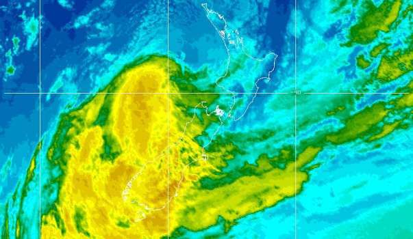
All severe weather warnings in the upper North Island have now been lifted, although there is still a GALE WARNING IN FORCE for the Raglan Marine area with a forecast for Sunday 16th of “Easterly 35 knots turning northerly 40 knots this morning then easing to northwest 30 knots this afternoon. Very rough sea easing.Southwest swell rising to 3 metres. Northwest swell 2 metres developing for a time. Poor visibility in rain, easing this afternoon.”
Yesterday’s winds brought some small branches and other vegetation down along SH 23. There was little rain with Raglan Weather recording only just over 6mm.
{SWW Event 2014/12.7}
NOT TO BE BROADCAST AFTER 09:00pm Sunday 16-Mar-2014
SEVERE WEATHER WARNING.
ISSUED BY MetService AT 8:10am 16-Mar-2014 URGENT – IMMEDIATE BROADCAST IN: Nelson, Marlborough, Canterbury, Otago, Buller, Wairarapa, Wellington, Coromandel Peninsula, Bay Of Plenty Rotorua, Gisborne, Hawkes Bay, Auckland, Waikato
EX-CYCLONE LUSI CROSSES NELSON AND MARLBOROUGH THIS EVENING. HEAVY RAIN TODAY FOR NELSON, MARLBOROUGH, BULLER, SOUTH CANTERBURY AND NORTH OTAGO. SEVERE NORTHWEST GALES THIS EVENING FOR THE MARLBOROUGH SOUNDS, WELLINGTON AND WAIRARAPA.
A depression – formerly Tropical Cyclone Lusi – lies west of Taranaki this morning and should move southwards to cross Nelson and Marlborough this evening. Wind and rain have eased in most North Island areas. Heavy rain warnings are in place today for Nelson, Marlborough, Buller, South Canterbury and North Otago. The heaviest falls today will be in western parts of Nelson where a further 180mm is expected. Rain in all these areas should ease or clear tonight.
As the low crosses the upper South Island Sunday evening, northwest gales are forecast to affect central New Zealand, and warnings are in place for Marlborough Sounds, Wellington, and Wairarapa south of Masterton. Gusts could reach 130km/h from Sunday evening to early Monday morning.
The heavy rain is likely to cause slips and surface flooding. The severe northwest gales could make driving hazardous, lift roofs, and bring down trees and powerlines. People are strongly advised to exercise caution, and to stay up to date with the latest forecasts, Warnings and Watches.
FOR THE LATEST WEATHER AND FORECAST CHARTS PLEASE GO TO http://metservice.com
