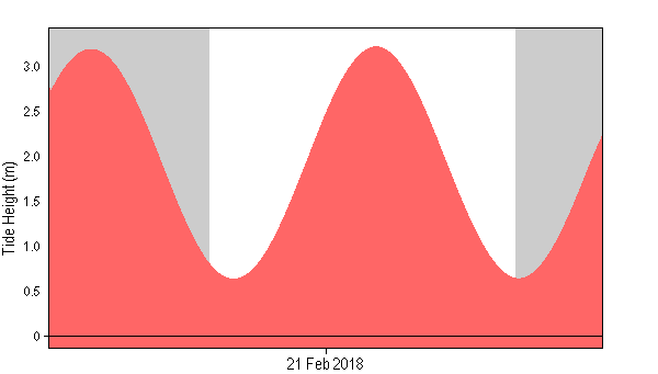
Although Cyclone Gita is expected to bring damaging winds and heavy rain to central New Zealand on Tuesday and early Wednesday, the Waikato is not included. Although there is no heavy rain or heavy wind warning in place, in Raglan there is a warning in place for king tide inundation.
The Raglan king tides are:
| 2018-02-20 | 13:26 | 3.30 |
| 2018-02-20 | 19:39 | 0.54 |
| 2018-02-21 | 01:49 | 3.18 |
| 2018-02-21 | 07:57 | 0.63 |
| 2018-02-21 | 14:08 | 3.21 |
{SWW Event 2018/0220.1106}
NOT TO BE BROADCAST AFTER 10:00pm Tuesday 20-Feb-2018
SEVERE WEATHER WARNING
Issued by MetService at 11:06 am Tuesday 20-Feb-2018
Cyclone Gita to bring damaging winds and heavy rain to central New
Zealand on Tuesday and early Wednesday
Cyclone Gita, currently located over the Tasman Sea, is forecast to
track southeastwards and cross central New Zealand late todayand
early Wednesday.
Note that the Watches for heavy rain for Christchurch, the Banks
Peninsula and North Otago have been upgraded to full Warnings.
The passage of Gita is expected to bring a period of high-impact
severe weather to central New Zealand. Heavy rain will cause slips,
rapidly rising streams and rivers, and flooding. Severe gales with
damaging gusts are expected, so people are advised to secure property
and items that may be blown away by strong winds.There is also the
potential for coastal inundation with high tide overnight Tuesday and
before dawn on Wednesday, due to the combination of tides, low
air-pressure, strong onshore winds and large waves in excess of 6
metres in some places. For the North Island, coastal areas from
Raglan southwards to southern Wairarapa are most at risk. For the
South Island, the risk of coastal inundation is greatest for areas
from Buller and North Canterbury northwards.
People are advised to keep up to date with the latest forecasts.
Please see http://www.metservice.
com/warnings/tropical-cyclone-activity for more detail on Cyclone
Gita, including the latest track map.

