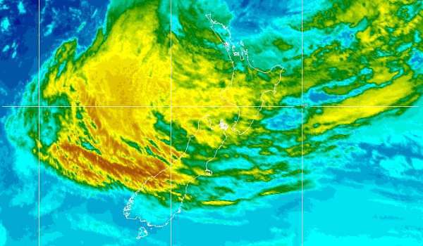
The MetService has a *** GALE WARNING IN FORCE *** for the Raglan Marine area forecasting that winds will be southeast rising to 25 knots on Saturday morning and to easterly 40 knots by midday. Sea becoming very rough. Southwest swell rising to 2 metres. Poor visibility in heavy rain.
However Cyclone Luisi is expected only to bring strong winds to the Raglan Whaingaroa land area and western Waikato. No warnings are in palce for these areas. In Auckland and Coromandel Peninsula, easterly gales will accompany the heavy rain, with severe gusts of 120km/h, and 130km/h in Thames and west of the Kaimai Range. More than 100mm of rain is expected in the Kaimais and Coromandel Peninsula.
This animated map shows how although the centre of the cyclone is likely to track west of Raglan, most of the severe weather will hit the east coast.
SEVERE WEATHER WARNING.
ISSUED BY MetService AT 8:30am 15-Mar-2014 URGENT – IMMEDIATE BROADCAST IN: Northland, Coromandel Peninsula, Bay Of Plenty Rotorua, Gisborne, Hawkes Bay, Nelson, Marlborough, Auckland, Waikato
CYCLONE LUSI WILL BRING HEAVY RAIN AND EASTERLY GALES TO MANY PLACES THIS WEEKEND A depression formerly Tropical Cyclone Lusi lies just north of New Zealand this morning and is expected to be centred about 300km west of Auckland at midnight tonight. The low will then move southwards to cross northern parts of the South Island Sunday evening. Widespread rain and easterly gales, already affecting northern North Island areas, are spreading southwards today. The heaviest falls today are expected about Coromandel Peninsula and western Bay of Plenty, where 150 to 200mm could accumulate. Heavy rain warnings are also in place for the eastern hills of Northland, the ranges of eastern Bay of Plenty and Gisborne, as well as the ranges of Hawkes Bay.
For the upper South Island, Marlborough and Nelson look set to receive the most intense rainfall, with 150 to 200mm possible in the ranges of northwest Nelson and 120 to 150mm about the ranges of Marlborough.
Easterly gales will accompany the heavy rain, with gusts of 120km/h in exposed parts of Northland and Auckland, and 130km/h west of the Kaimai Range. These gales are expected to gradually ease from this evening.
This will be a significant adverse weather event, affecting many parts of the country. The heavy rain is likely to cause slips and surface flooding, and the severe easterly gales could make driving hazardous, lift roofs, and bring down trees and powerlines. People are strongly advised to exercise extreme caution, and to stay up to date with the latest forecasts, Warnings and Watches.
FOR THE LATEST WEATHER AND FORECAST CHARTS PLEASE GO TO http://metservice.com
